
記住我
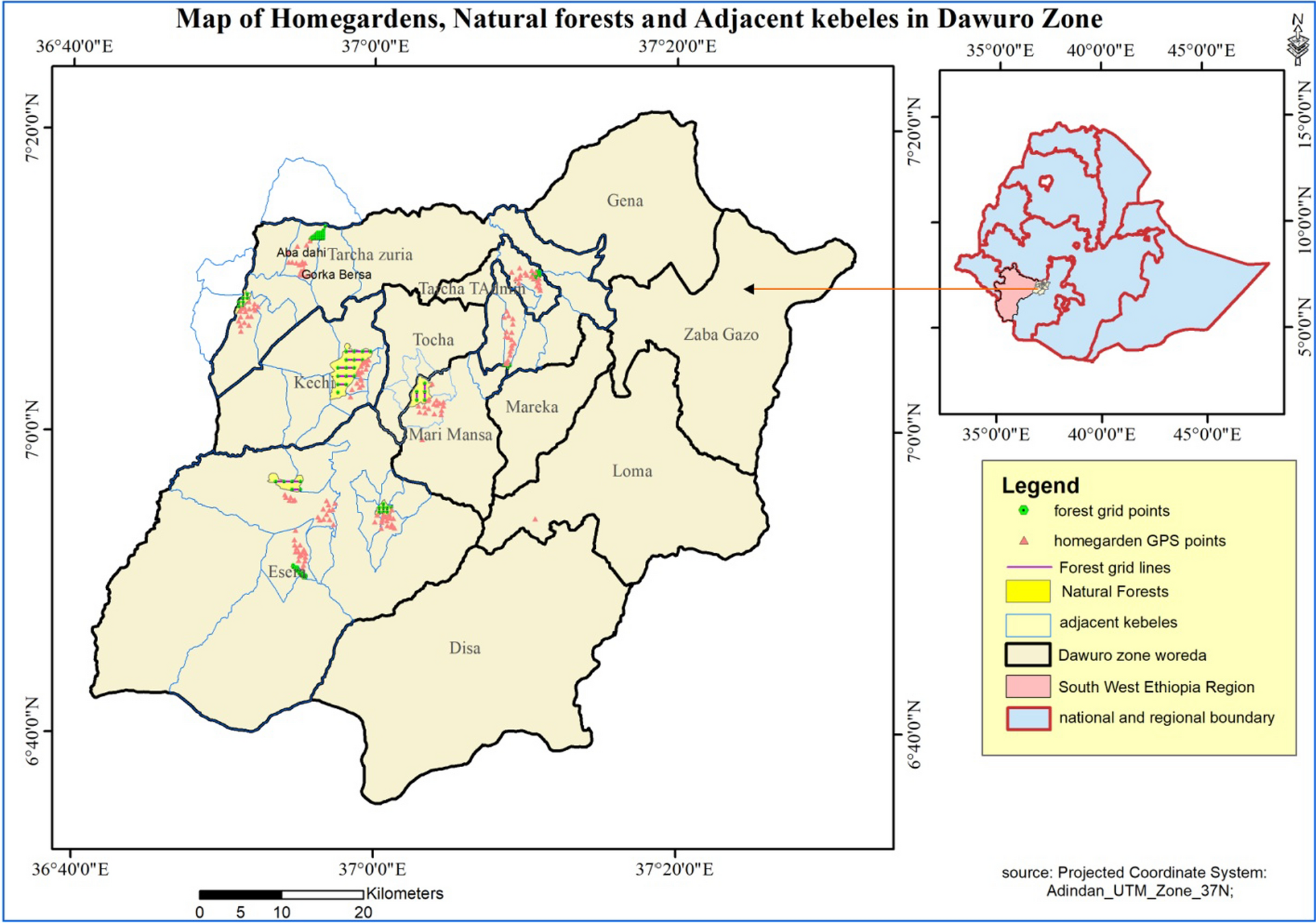


The research was conducted in the remaining Quilombo community of São Roque Pedra Branca (in Brazil, the word “remaining” refers to communities that remained in different places after the end of slavery), whose territory is within the Atlantic Forest domain in southern Brazil (Fig. 1a, b). Located between the municipalities of Praia Grande/Santa Catarina (SC) and Mampituba/Rio Grande do Sul (RS) (Figure c, d), the São Roque community (29°15′15″ S 50°06′46″ W) has 82 people and 32 families and an average of 45 people living within the delimitation of the traditional territory. The community has a history of occupation of this territory since 1824, associated with the transit of enslaved peoples who farmed in the coastal plains of Serra Geral, accompanied by the “Senhor do Engenho”, (or the lord of the farm), slaveholders and farm owners from that time from São Francisco de Paula [33]. Thus, the time of occupation in this territory by the enslaved people and their descendants counts for more than 180 years. On June 17, 2004, the community was recognized as a Quilombola community by the Palmares Cultural Foundation [34], with the Technical Report of Identification and Delimitation published in 2007. The process of territorial regularization is still underway through the Brazilian Institute of Colonisation and Agrarian Reform (INCRA). Formerly, the community was known as the Pedra Branca community, because of the geological formation that provides one of the community’s postcards, as a tourist destination (Fig. 2).
Fig. 1
Geographical representation of the Quilombola Community in Brazil and southern states. a and b Geographic location of Quilombola Community of São Roque; c overlapping areas of the Quilombola territory (SR) and National Parks Aparados da Serra (PNAP) and Serra Geral (PNSG); d Quilombola territory (SR)
Fig. 2
Local landscape view of the Quilombola Community and its surroundings. a Quilombola banana plantation with Pedra Branca in the background; b part of the territory of the Quilombola community São Roque, and Rio Mampituba seen from the top of Pedra Branca; c Quilombola house with Pedra Branca in the background. Photographs by Danilo Barreto
The original Quilombola territory has about 7 thousand hectares, with 36.42% of this area overlapping with two protected areas: the National Parks of Aparados da Serra and Serra Geral (Fig. 1b). These protected areas were created in the 1960s and 1990s, respectively. In those protected areas, the percentage of the traditional Quilombola territory is 36.42%, and of this percentage, the current community use in areas overlapping the national parks is 0.078% of the total parks area, but the intended percentage is 9.69% [33]. Due to this overlapping with two national parks, the São Roque Quilombola community faced conflicts related to the management of natural resources for a long time. Based on a Term of Commitment signed in 2013 and in force since 2016, the status of use of the territory and its resources were recognized as legitimate by the environmental agency; however, the long history of conflicts still has details that need to be resolved. Today, in addition to participating in the management council of the parks with the environmental agency, the community participates in community-based tourism actions, also focusing on conservation, territorial management and environmental education.
Data collectionThis research followed the ethics guidelines of research with human beings of the Universidade Federal de Santa Catarina, with previous free informed consent for all data collection (see Supplementary Material 1). In the first step of this research, from November 2018 until June 2019, we interviewed all 44 residents of the community who were over 18 years old, and who lived in the original territory, being 25 men and 19 women. Semi-structured interviews were carried out to collect socioeconomic information, and a free listing technique was used to register the native plants known and used by each interviewee.
We then collected botanical samples of the main species mentioned in the interviews, for botanical identification. Most of the species collected were identified and had their determination confirmed by specialist Dr. Pedro Fiaschi from the Botany Department of the Federal University of Santa Catarina (UFSC). Plant vouchers were deposited in the EAFM herbarium of the Federal Institute of Education, Science and Technology of Amazonas, which has an ethnobotany collection (vouchers 13,013; 13,035; 13,041; 13,043; 13,056; 13,090; 13,108; 13,116; 13,117; 13,124; 13,128; 13,154; 13,169; 13,170; 13,221; 13,291; 13,335; 13,337; 13,405). For some species, it was only possible to collect non-reproductive vegetative material, making their detailed botanical identification impossible.
In the following months, and following suggestions of the community members, we organized one participatory workshop with four activities to collect data about the community’s perception of the intensity of harvesting, environmental availability, and cultural importance of plant species previously selected from the interviews. The workshop happened on July 20, 2019, during the whole day, in the São Roque Communitarian Center. We organized the groups for the workshop based on the gender of the participants, in two simultaneous working groups for the first, second, and third activities. The fourth activity was done with the whole group. Twenty-two adults participated in the activities (nine women aged between 25 and 65 years old, and thirteen men, the youngest aged 24 and the oldest aged 71 years old. The activities of each group were facilitated by a team of three people external to the community, responsible for guiding the activities, recording the participants’ speeches, and taking photographs. The first author supervised and coordinated all activities, to ensure the timing of both groups in the first, second, and third activities, and to register qualitative details that could arise as the workshop was going on. In the women’s group, only women researchers facilitated the activities, and the same was done with the other group, with only men researchers. This choice was made due to the recognition of the interlocutor as a similar, which provides a comfortable environment for the manifestation of the participants’ knowledge [35], besides providing more accurate information [36]. All the people interviewed in the previous stage of this research were invited to participate in the workshops.
In the first part of the workshop, we proposed the four-cell tool activity, adapted from Zank et al. (2015) [19]. For this step, we selected the most important native plant species using the criterion of frequency cited to each species in the previously free listing interviews, but with the flexibility to include other species according to suggestions of the workshop participants. We drew a graph in which the horizontal axis represented the harvesting intensity and the vertical axis the availability of species in the territory (thus, the bottom quadrants indicated low availability and the right the ones with high collection intensity). In each group the participants were asked to locate each of the previously selected plants in the quadrants. The risk status of each species was accessed by consulting the National Flora Conservation Center (CNCFLORA) national list of extinction risk for the Brazilian flora [37] and the state red lists of Santa Catarina and Rio Grande do Sul [38, 39].
In the second part of the workshop, we used an environment matrix and invited the participants to indicate the environments where the selected species were found. We used amounts of seeds (from a local variety of beans) to estimate the abundance of each species in a table that listed the environments previously mentioned in the interviews and the species. Before starting the activity, the participants were asked about the characterization of each environment. As in the first activity, it was also possible to add environments that had not been previously selected.
During the afternoon, for the third part of the workshop, we invited the participants to discuss the value and importance of each plant species. The species were compared with each other regarding their importance for each group. Three levels of importance were established in a ranking matrix (very important, important, and not very important) and a maximum of five species could be allocated to each level. The participants of the workshop considered “not very important” those plants that did not have a recognized direct use, “important” were those that had some use, and “very important” were the main plants used for the community (among all categories of use, but especially medicinal use).
To conclude the workshops, the third and fourth authors, who are Quilombola elders unanimously recognized as specialists in plants, shared their knowledge about the uses and preparation of remedies with forest species. They are brothers, whose houses and land are located in the area overlapping with the National Parks, which made the practice of agriculture and the use of traditional species unfeasible for some years due to conflicts between the community and the environmental institution. This part of the workshop was requested by the community, also being a form of appreciation for the community’s permission and contribution to the research.
Data analysis followed a qualitative approach and was based on Zank et al. (2015) [19] and Poderoso et al. (2017) [40]. To analyze the gender characteristics related to the knowledge about the plant species, we contrasted the responses of the groups in each activity and also compared the results with the free lists previously made.
留言 (0)